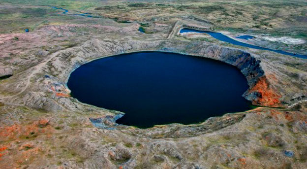
ISTC project on comprehensive radioecological research in the vicinity of the “Atomic Lake”

On April 1 a second ISTC project “Assessment of ecological risk after excavation nuclear tests: “Chagan” underground nuclear test conducted at Semipalatinsk Test Site, the Republic of Kazakhstan, a case study” started. As a reminder Semipalatinsk Test Site (STS) was one of the largest test sites for testing nuclear weapons across the globe. Nuclear tests were conducted between 1949 and 1989 in the STS territory. It should be noted that the greatest contribution to radioactive contamination of the test site area has been made by aboveground and excavation explosions compared to high-altitude ones. The objectives of this Project are:
  • Evaluation of the impact of the “Atomic Lake” and artificial water reservoir conditions on the ecosystem in the region.
  • Development of suggestions to use the “Atomic Lake” for scientific and economic purpose.
To achieve goals set, 4 major tasks are to be solved during the first year of the project: 1. Generalization and analysis of archival information; 2. Comprehensive radioecological research near the “Atomic Lake”; 3. Study of seasonal variability in radioecological parameters of environmental sites at the “Atomic Lake”; 4. Processing and analysis of findings. The chief contractor of this project is the branch “Institute of Radiation Safety and Ecology” RSE NNC RK. The Fukushima Environmental Safety Center, Japan Atomic Energy Agency acts as a collaborator. During the project implementation it is planned to obtain data on the nature of areal distribution of artificial radionuclides in the territory of the “Atomic Lake” site; study the process of wind erosion in dump edges of the “Atomic Lake” and obtain figures of radionuclides entry into atmospheric air in various weather conditions; obtain data on radioactive contamination in water of water body surfaces of interest by identifying dependencies on different physical and chemical parameters; determine factors of radionuclides transfer from bottom sediments to aquatic vegetation; design a GIS project that reflects results of studies including all the spectra accumulated and processed (by using a pedestrian and gamma-spectrometric survey). Research undertaken under the project based on the system designed using GIS technologies, allows to continue development of a new line in designing scientific and methodological fundamentals for preparing and conducting comprehensive studies on contamination levels of sites affected due to radiation accidents and tests of nuclear weapons. Results of comprehensive studies of the “Atomic Lake” location will serve as a basis for defining the major factors that influence the migration of radionuclides in environmental sites as a result of an excavation nuclear explosion. Based on processed findings, a guideline basis will be created to give an integral estimate to geoecological situation of the environment near the “Atomic Lake”. Data on doses to population given behavior scenarios as well as a summarized diagram of values of the integrated index showing zones of revealed and expected ecologically adverse areas will be the foundation. Based on such data, recommendations will be given for restraining the adverse impact of the ecological situation emerged in the vicinity of the “Atomic Lake” on the population and the environment. The project will assist in solving the international problem on the study of nuclear consequences for different media and radioactive contamination of territories as well as in supporting applied research which in turn would allow to develop measures aimed at rehabilitation of the environment.